 CoveGuard
A bay that sheltered you beautifully in a sirocco becomes a trap once the bora arrives. If the wind is due to shift 45 degrees within six hours, we'll say so. At ninety, we treat it as serious.
Beta is live — looking for testers
The sailing copilot that thinks ahead.
CoveGuard watches your anchor while you sleep, plans your passage against real forecast weather and warns you before things go wrong. Built for the Adriatic. Works without a signal.
7,846anchorages on file
2 kmCroatian ALADIN model
1,975places with a story
120lighthouses on file
6,161anchorages with known seabed
6,863charted hazards
137rescue centres on file
30,984points of interest ashore
A principle we won't move on
You never pay for safety here. And you never will.
The anchor alarm, distress calling and man overboard will never sit behind a subscription. Features that lives hang on have to work for everyone — including someone who downloaded the app ten minutes ago. No account, no trial period, no reaching for a wallet. This isn't a first-season promotion. It's the condition we set out under.
And it isn't just the buttons for the worst moment. Everything that helps you stay out of it — or climb back out — stays free too: emergency numbers, the nearest coastguard station for where you are, hospitals and pharmacies on the map, first aid that works with no signal.
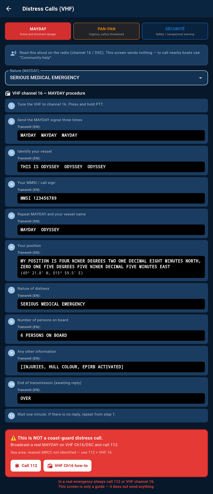
And one thing we're particularly proud of: the app writes the distress call for you. Who is calling, from where, what is happening, how many souls are on board — laid out in the order it has to go out over the radio. When the skipper is busy with something else, or is the one in trouble, the crew isn't helpless: they read it off the screen.
And let's be plain about money. We're not out to make money off sailors — we're trying to make sure the app is still here in five years. Servers, live weather and data sources all cost money, so in time there will be premium features that pay for running it. They'll be extras, not a lock on what you use today. Safety and downloaded maps stay free for good — and that isn't just a promise on a website, it's held in place by a safeguard written into the app's own code.
Anchor watch
Konoba — watch from ashore
SOS & distress
Man overboard
Search patterns
Distress call generator
VHF distress calls
MRCC quick dial
Rescue centres
SMS when data fails
Hospitals & pharmacies
First aid offline
Pressure-drop alert
Help nearby
Pre-departure check
Weather warnings
Anchor watch
You sleep. It doesn't.
Drop the pin where your anchor is and tell it how much chain you veered. CoveGuard then checks that the boat stays inside the safe area — in the background, with the screen locked, all night.
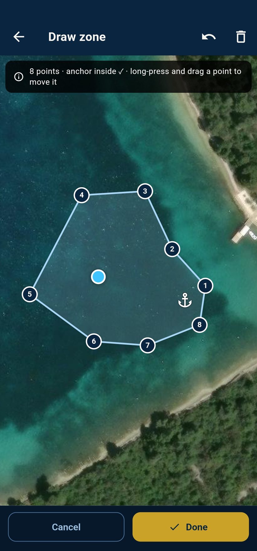
- A real shape, not just a circle. Draw the safe water to match the bay instead of settling for a radius.
- Scope advice that uses the seabed. Depth, bottom type and the forecast decide how much chain it suggests.
- It watches what is still coming. If the forecast has the wind veering or building, you hear about it in advance — not after the boat has already moved. Nobody can predict an anchor letting go, and we don't pretend otherwise.
- It checks on itself. If GPS drops out or the watch stalls, it tells you — instead of quietly stopping.
How we watch — without waking you for nothing
- It catches slow dragging too. We watch two things at once: how far you are from where the anchor went down, and whether the centre of the arc your boat swings through is shifting. The second one catches dragging of a few metres an hour that still fits inside the circle. And when the phone itself reports a fix accurate to worse than twenty metres, the watch keeps it out of the decision — it would rather wait than wake you over a GPS jump.
- Before it starts watching, it checks the sound. It plays a test tone out loud and asks whether you heard it — without your confirmation it won't start. It's just as firm about location: in your phone's settings it wants “Allow all the time”. And if you deny it something, it tells you plainly that it's running in reduced mode.
- The alarm rings like an alarm clock, not like an incoming call. It sounds even with the ringer off, lights up the locked screen, and the phone vibrates with it.
- In wind it makes up its mind faster — but it won't shrink your zone. Before it sounds the alarm it wants dragging confirmed by several fixes in a row: in calm it waits for five GPS fixes and thirty seconds; in wind, three fixes and twelve seconds are enough. What it will never do is shrink the zone you drew.
- A snooze that undoes itself. Snooze the siren for five, ten or fifteen minutes. The app remembers how far from the anchor you were at that moment. If the boat then drags ten metres further out than that (15% of the radius on large zones), the siren is straight back. Snoozing never stops the watch, only the sound.
- It survives a reboot. Turn off the screen, switch apps, restart the phone — the watch keeps running. A permanent notification with an off button stays in your status bar, so it never runs behind your back.
- In the morning you see what she did all night. The track across the water, a map of where she sat longest, how far she wandered, how often she came near the edge of the zone, and how the pressure moved overnight. With no measured data, you see nothing.
What the app watches while you sleep
No clever talk about artificial intelligence. It's six specific things, checked on our server every fifteen minutes — while the app is closed and the phone lies locked in the cabin.
Not how hard it's blowing now — that the forecast has got worse since the last check. Eight knots more in the gusts is a warning; fifteen is an alarm.
The app knows which way your bay is open and watches that bearing. Fifteen knots from the exposed side does more than thirty off the lee of a hill.
It is watched by your position, not by a planned route — the app only needs to know where you are. It speaks up the moment the first model shows the bora, and then stays quiet until that episode is over.
It isn't enough that it's raining somewhere — the app works out how strong and how big that cell is, where it's going and when it reaches you. When the answer is twenty minutes, it's time to act, not to study the chart.
This is measured by the barometer in your own phone. Alone on this list it works with no signal and no server — when you're completely cut off, this watch stays with you.
The exact thresholds, so you can check us — the first number is a warning, the second an alarm: veer 45° / 90° within 6 h · gusts +8 / +15 kt above the last check · wind into the exposed sector 15 / 25 kt · bora from the north-east gusting 28 / 45 kt within 12 NM of you · radar cell core from 8 mm/h and area from 25 km², passing closer than 6 km and reaching you within 90 min (critical inside 20 min) · pressure −3.6 hPa in 3 h or −2 hPa in one.
One distinction worth keeping: these are weather warnings. The anchor alarm with the siren is a different thing — dragging sets that off, not a forecast.
Konoba — watch from ashore
The boat is in the bay. You're at dinner.
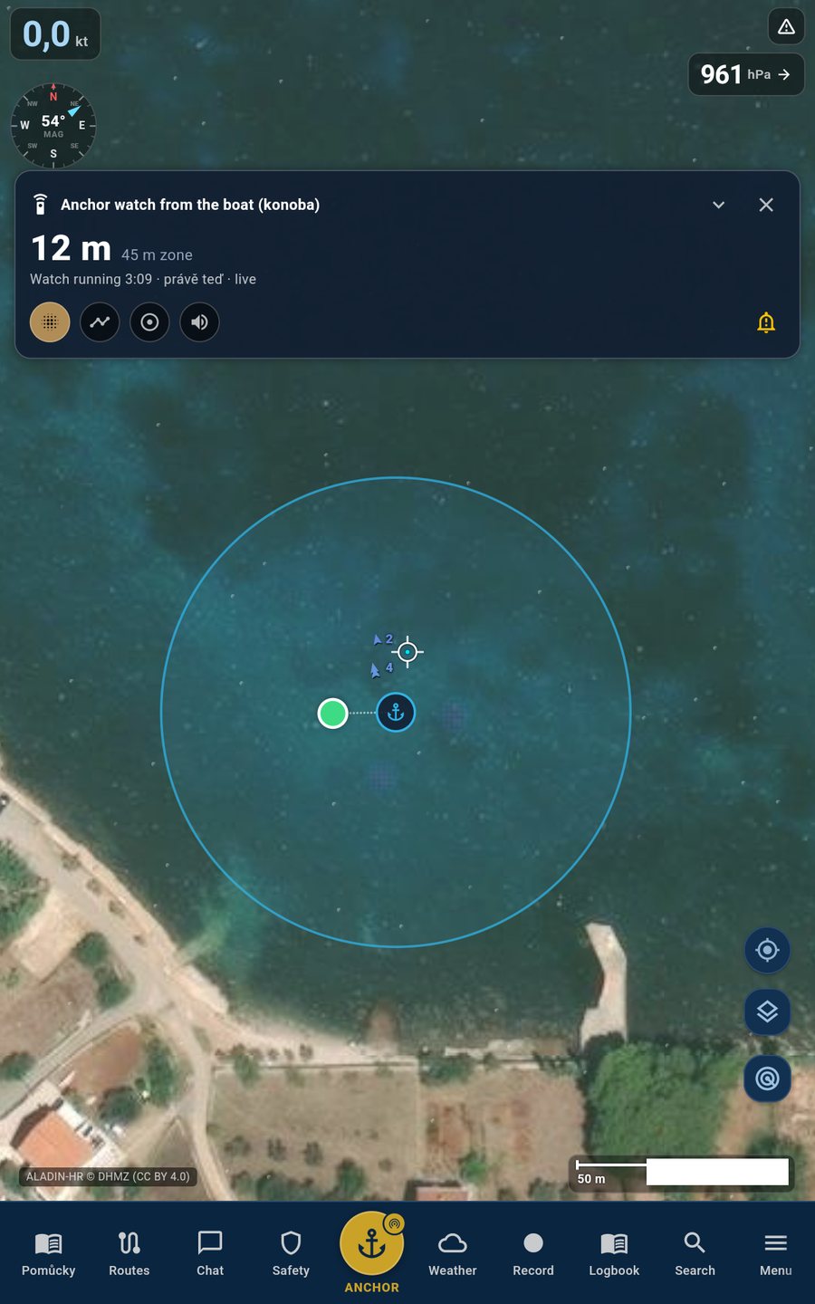
When you leave the boat, someone from the crew can take the watch from the shore. They see her live on their phone and get an alert the moment something changes.
- It speaks up when she goes quiet. Not only when the anchor drags — also when the boat stops reporting at all.
- The siren can be silenced remotely, so a false alarm doesn't wake the whole anchorage.
- The watch itself can't be switched off. Whoever is keeping watch from shore can mute the sound — but not switch the watch off.
Weather
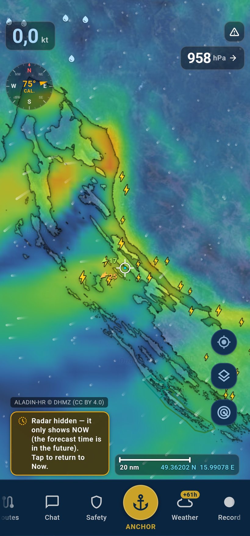
The Croatian ALADIN, not the Czech one.
ALADIN isn't one model but a family — sixteen national weather services run their own. Over the Adriatic, apps like Windy and Windguru show you the Czech one, from CHMI, computed on a Central European domain. CoveGuard reads ALADIN-HR straight from the Croatian DHMZ — the service that issues the official forecasts and warnings for the Adriatic.
- Wind is worked out separately, and in more detail than the rest of the weather. The Croatians go to the trouble of running wind and gusts through the model a second time, on a denser grid of points. They do it because of the bora — and we get the benefit.
- The bora doesn't blow evenly over the mountains. It bursts out in jets from individual saddles in the Velebit ridge, with near-calm water in between. Coarser models smear that into one broad band — so you expect a quiet afternoon exactly where it's howling.
- We don't invent the gusts. We don't take mean wind and multiply it by a factor; we take the gusts the model itself computes. The model works out on its own that the wind tears twice as hard under Velebit as in open water — nobody told it where Velebit is.
- So you see what an average hides. Off Dubrovnik the mean wind came out at 4 knots — and the gust at 43. Multiply a light wind and it stays light; you'll never find a squall that way.
- When the gusts are missing, we'd rather say nothing. We reach for another model instead of filling the gap with a guess and pretending we know.
- Pressure from your phone — and from the boats around you. It's measured by a sensor in the phone itself; it isn't downloaded data. And if your phone hasn't got one, no matter: in CoveGuard we share readings with each other, so you'll still know whether the pressure is falling on the boats nearby.
- A second 2 km model south of the Adriatic. ALADIN‑HR stops at the Croatian border; Montenegro, Albania and the Ionian are covered by Italy's ICON‑2I at the same resolution — so you see the wind in detail there too.
- And observation, not just a model. Rain radar from the European network, satellite rain where the radar can't reach, satellite lightning across the whole Mediterranean, and official severe-weather warnings — not just our own reading of the data.
How fresh your data actually is
At anchor, the age of a forecast isn't a detail — it's safety information. So for every model you can see how old the forecast in front of you is — “just now”, “40 min ago”, and after a day simply “STALE”. A week without a signal and the app still draws the last forecast it downloaded, but it doesn't pretend it's fresh.
A forecast isn't ready the moment it starts to apply — the models have to finish running and the source has to publish them, which typically takes about three hours. And here's the part we cared about most: most apps go looking for data at fixed times, because “that's usually when it lands”. Instead, every fifteen minutes we ask the source directly whether it holds a newer forecast than the one we've already downloaded. If it does, we fetch it straight away. If not, we do nothing and leave the source alone. We keep a fixed download time too — but only as a handbrake in case that checking ever breaks.
| Source | Published | Forecast | We check |
|---|---|---|---|
| ALADIN‑HR · 2 km, Croatia | 2×/day | 3 days | every 15 min |
| ICON‑2I · 2 km, Italy & the whole Adriatic (incl. the south) | 2×/day | 3 days | every 15 min |
| ICON‑EU · 7 km, Europe | 4×/day | 3 days | every 15 min |
| ECMWF · IFS 0.25°, global | 4×/day | 3 days | every 15 min |
| GFS · 0.25°, rest of the world | 4×/day | 3 days | every 15 min |
| Rain radar · OPERA network | new frame every 15 min | 6 h loop | every 5 min |
| Satellite rain · H SAF H40B (EUMETSAT) | every 10 min | fills gaps the radar misses | every 5 min |
| Satellite lightning · MTG‑I1 (EUMETSAT) | continuous | whole Mediterranean | every 5 min |
| Official warnings · MeteoAlarm, DHMZ | continuous | — | every 15 min |
ALADIN‑HR and ICON‑2I are computed mainly for wind, so the rain forecast comes from a model with full coverage. But the rain that's actually falling we show from observation, not a forecast: ground radar where it reaches, and satellite rain where it can't — the southern Adriatic and the Aegean. And a storm we flag from what's visible — observed radar and satellite lightning — not from a model's guess. We put that here deliberately: better we tell you how it is than you find out the hard way.
Not just the forecast — how well it's landing today
We continuously compare the forecast against what the DHMZ coastal stations actually measured, and for every model you can see how well it fits your spot today — how far off it is on wind and direction, and how often it "hits". No model is best everywhere and always; this tells you which one to trust more here, right now.
Anchorages
How sheltered is this bay — today?
Every anchorage gets a shelter score that moves with the forecast, rather than a fixed star rating from a pilot book. And the bottom type comes from a real European seabed layer, not a guess based on where the bay happens to sit.
- Shelter over time. A bay that is tucked away this afternoon can be exposed by midnight. You can see exactly when it turns.
- Bottom type from data. Mud, mixed ground, sand or weed from the European seabed map — for four out of five Croatian anchorages. The Adriatic is largely mud, and close inshore these charts average rock away, so you will rarely see it in the data.
- Where you must not anchor. Posidonia — protected seagrass. Line the anchor up over it and the app warns you before the anchor ever goes down. The check runs on the phone itself, so it holds with no signal at all. We add the anchoring bans we know about — and since the rules change and nobody holds a complete list, we're counting on you. What you report, everyone sees.
- An honest "we don't know". Where there is no data, we don't invent any.
- What other crews found. Reviews, photos and occupancy questions from boats already there.
Ship's log
A logbook that writes itself. And doesn't lie about engine hours.
She starts moving and the passage starts recording. In the morning you have the track, the stops and the night at anchor — and you typed none of it.
- Engine hours are never worked out from speed. We only add up the legs marked as motoring — and if nobody marked anything on a passage, we write no engine hours into the log at all. Elsewhere, a sailboat that spent six hours under sail ends up with six engine hours.
- The track survives a crash. Every GPS fix is written to the phone straight away, not at the end of the passage. If the system kills the app mid-trip, the track is whole — and on the next start it asks you what to do with the unfinished record.
- Drag your finger along the timeline and the passage replays. Under your finger runs what was happening at that moment — heading, speed, wind, pressure, position. At the same time, a dot on the mini-map jumps to where you were right then.
- It notices stops on its own. Stay put long enough on passage and it offers to log one — a swim, shopping, fuel, a repair. And if you only remember that swim in the evening, you pick it and the app offers the times the boat was stopped there.
- You fix up the passage; the original GPS track is never overwritten. Trim it, split it, merge it, mark leg by leg where you motored — and undo any of it whenever you like. None of it is ever written into the original track; that stays exactly as the receiver recorded it. These after-the-fact edits don't carry over to a second device yet.
- It writes place names, not coordinates. “Off Vrgada island” — and it manages that without a signal, because it keeps the list of 370 Adriatic islands, 80 coastal settlements and anchorages on the phone itself. When there's nothing real nearby, it would rather write nothing.
- The export looks like a ship's log. A4 portrait, one day per page, vessel and skipper in the header, a watch table of ten columns and daily totals at the bottom. What the app doesn't know is a dash, not a zero. Besides PDF there's CSV, GPX and plain text.
The exact thresholds, so you can check them: recording starts after 60 seconds of sustained 2–18 kt (above that it won't start on its own, though a recording already running carries on — a fast passage never gets cut short) · a longer stop is offered after 20 minutes (adjustable 10 to 45) · the passage pauses after 10 minutes below 0.7 kt · and is closed for good by a stop over three hours or by crossing 02:00. Under way the log writes one line an hour, the way a watch does, and a weather snapshot at most every three hours. The log keeps the last year; anything older is deleted on startup, so don't put the export off.
And the rest
Everything else a passage asks for.
Instruments from the boat
If your boat has a WiFi gateway to the plotter (it puts the instrument readings on the network), the app finds it by itself — no copying IP addresses out of a manual. You get live speed, heading, depth and wind; across the app those readings take priority over the phone's GPS and are marked INS, short for instruments. If nothing new comes from the boat for six seconds, the app falls back to GPS and simply stops showing depth — better blank than a stale number. If the boat has a barometer, the log takes the pressure from there instead of from the phone. And if the boat has its own AIS receiver, we draw nearby vessels from it, with no internet at all.
Passage planning
A route under power or under sail, tacking included, with an estimate of time and fuel. It warns you about ferry lanes and about bridges you won't fit under.
Ship's log
The passage writes itself — track, engine hours, fuel used. Add photos and notes, export as PDF or GPX.
Boat & crew
Boat profile, maintenance and repairs. The crew briefing speaks six languages — English, Czech, Croatian, Italian, Slovenian and German — so a mixed crew each reads it in their own.
Distress & first aid
SOS with the call already worded for you, man overboard with drift and a recovery turn. No data? It falls back to SMS.
Places with a story
What that cape, cave or island actually is and how it got its name. Close to two thousand places, in English and Czech.
What am I looking at
Point the phone at the horizon and it names the light or the island in front of you. From compass and position, no internet needed.
Handbooks on board
The rules for preventing collisions, the system of marks and buoys, first aid and VHF channels. All of it offline, even with no signal.
Go or wait?
Before you slip the lines, it folds wind, sea and warnings along your route into one recommendation — and tells you why.
Where to fuel up, and what's nearby
Fuel docks, shops, restaurants, water and repairs straight on the chart. 396 fuel docks and over a thousand places to find medical help. At fuel docks we also ask for the depth alongside: whoever fills it in saves the next skipper a nasty surprise. This is exactly the kind of thing only a community can supply.
Boats around you
Who is nearby, chat with your crew and with the bay. You share your position only when you want to, and can stop any time.
At sea, not at a desk
The signal stops. The app doesn't.
Charts, handbooks and the downloaded forecast all work without internet. The anchor watch needs nothing but GPS. And at night the screen won't blind you.
12.4
DayReadable in direct sunlight12.4
NightMuted colours for sailing after dark12.4
TacticalRed, so your night vision survivesWhere it works
The Adriatic is home water. Greece works too — we just won't pretend it's the same.
CoveGuard was built for the Adriatic and it shows. Wind comes from the Croatian ALADIN model at 2 km with a real gust field, seabed type and posidonia meadows come from European datasets drawn for the Croatian coast, the anchorage catalogue includes marinas and mooring fields, and official warnings come straight from the Croatian met service. All of that stops at the edge of the Adriatic. We added Greece because people sail there and because a large part of the app works there without compromise — not so we could print a second country on the box.
What works the same in Greece
- The anchor watch and alarm, distress calling and man overboard.
- The map with satellite imagery and offline area download.
- Depth and seabed slope from the European EMODnet database, precipitation radar from the OPERA network.
- Forecasts including gusts, plus the shelter score for bays. There's now a 2 km model for the Ionian and western Greece too (Italy's ICON‑2I); the far eastern Aegean, beyond its reach, is covered by coarser global models (~7 km and up). The app always tells you which model you're seeing, and on the coarser grid wind funnelling through a narrow strait gets smeared out.
What doesn't
- We have no seabed-type data and no posidonia map. We won't tell you what you're dropping the hook into, and we won't warn you off anchoring in protected seagrass — and Greece does fine you for that.
- We don't ingest Greek official warnings. An empty warnings panel there does not mean nothing is in force.
- The anchorage catalogue is thinner. Named bays from OpenStreetMap, no marinas, no mooring fields — and names often in the Greek alphabet, so Latin-script search won't find them yet.
- Rocks and wrecks are shown, but it's raw community data. Densely mapped in the Aegean, almost blank in the Ionian — and an empty patch on the chart is not proof of clear water.
- Curated places, ferry corridors, island labels and live vessel positions from our server are Adriatic only.
Until we close that gap, you'll hear it here rather than in a store review.
Who it's for
For whoever answers for the boat.
Charter skippers
One week in cruising grounds you don't know, with a crew that is counting on you. CoveGuard fills in the local knowledge you haven't built yet.
Boat owners
Your own boat, favourite bays, the same passages each season. A log, maintenance records, and peace of mind when she's left at anchor on her own.
Professional skippers
A full season on the water. Something solid behind the decision to sail, and a record of what actually happened.
Why CoveGuard exists
We got fed up with safety being sold.
The big players cash in on sailors' safety. Their charts are missing critical details — or they charge a fortune for them. Yet it is in all our interest to get safely from A to B and bring the boat and the crew home in one piece.
So we decided to map those coves, shallows and warnings ourselves — legally, and as a community. The part that keeps you safe at sea stays free. Forever.
This only works if we build it together.
The app is in its infancy and we won't pretend otherwise. Coves, depths, local warnings — all of it has to be filled in by the people who are actually there. We will never assemble it from a desk.
We'll sound the depths ourselves. Every passage can contribute a depth reading, and out of that data a picture of the seabed slowly grows. One day it will become a marine navigation system of our own — built by the community, and therefore free. Not because we're generous, but because overpriced corporate apps annoy us.
AIS will go the same way. The technical side already works, but it only becomes useful once enough boats share. Without a community it's an empty chart.
And it runs both ways: whatever you put into the app comes back to you. We'll shape it around how you actually sail — not around what someone in an office imagines sailing to be. From you for us, and from us for you.
To be clear: we are not a navigation app today, and we don't want you using us as one. We can work out a route, but treat it as a fallback for when everything else has failed. Navigation belongs to official charts and approved instruments — and that is where it stays for now.
By sailors, for sailors — people helping people.
Where we want to take it
What you see today is the foundation, not the goal.
What you see in the app today is a start — and what gets built on it will be decided by what sailors need. We're not making a product for investors or for a feature list on a box. We're making it for people who are actually out there at sea.
Charts cost hundreds a year — and plenty of skippers open them once a year for one week of holiday. Once there are enough of us for our echo sounders to add up to a depth map of the Adriatic, we stop depending on the big publishers. What we measure together stays ours together.
We can already do it technically. What's missing is enough boats sharing their positions — and once there are, everyone will see them. No subscription, no cap on vessel count, no turning awareness of the traffic around you into a premium tier.
We add data where people sail most and where they want it. The Adriatic is done, Greece is next in line — and what comes after that will be decided by where the people using the app come from. We're not promising the whole world within a year. We're promising to go where we're needed.
We'd like to add more forecast models. And let's be honest: the good ones cost money we don't have today. They'll come when the community and voluntary support cover the bill — we won't promise them before that.
Free beta
We're looking for skippers who'll take it to sea.
CoveGuard is in a free beta for Android. No cost — in return we're hoping for honest feedback from people who actually sail.
And we won't forget the people who help us knock the beta into shape. When paid extras do appear one day, we fully intend for anyone who was here from the start to keep better terms with us, permanently. We take that as a given, not as marketing.
And iPhone? Not yet — and we're not going to promise you anything. First we want to finish Android to a standard we don't have to be embarrassed about. Building an iPhone version means a different approval process, more cost, and above all divided attention, which for a small team is the most expensive item of the lot. It will get its turn, but not before Android is properly done. So it’s not left vague: don’t expect an iPhone version before mid-2027 — and even that isn’t a promise, just the earliest date worth saying out loud. Until then, all our attention goes into polishing the Android app.
How to get in. The app is on Google Play — use the badge below. Reading this on a computer? Point your phone's camera at the QR code and the store opens right there.

 Scan with your phone
Free · Android · Adriatic and Croatia for now
Where the data comes from
We tell you what you're trusting.
No app replaces a nautical chart and your own judgement. That's why every layer on the map shows where its data comes from and how accurate it is.
DHMZ — ALADIN-HRAdriatic forecast at 2 km resolution. Croatian Meteorological and Hydrological Service, CC BY 4.0.
OpenStreetMap & OpenSeaMapBase chart and sea marks. © OpenStreetMap contributors, ODbL.
EMODnetDepths and seabed substrate from the European marine database. CC BY.
EUMETNET OPERAEuropean weather radar network.
Wikimedia Commons & WikipediaPhotographs and text for places and handbooks, each under its own licence with attribution.
ICON‑2I2 km forecast for Italy and the whole Adriatic. Agenzia ItaliaMeteo and Arpae, CC BY 4.0.
ICON‑EU (DWD), ECMWF, GFSForecast for Europe and the rest of the world beyond the finer-grid model.
EUMETSATSatellite rain (H SAF H40B) and satellite lightning (MTG‑I1 Lightning Imager). © EUMETSAT.